The Legend of Lemuria – Part Four
In a news article published by the New York Times on October 28, 1921, the famed American automobile magnate Henry Ford made the memorable comment, which has since been repeated innumerable times, when he said: History is bunk!
Now Henry Ford’s remark was directed more toward his attitude that events that happen in the present are more important than things that have happened in the past. But there was more wisdom in his words than he might have imagined at the time.
In an essay devoted to this point, noted columnist Patrick Lockerby wrote:
“In archaeology and library research you can make a claim based on the easy pickings that lie on the surface or you can break into a sweat as you dig deeper. But it is not enough to dig deep. You must sift every spadeful, and sift it fine. Truth is most often found in the tiniest of grains: it is easy to miss if you don’t focus intently.” (View Source)
His point goes to the very heart of the historical dilemma. The history of the past is invariably written, and rewritten, by the historians of the present. And it is often their misinformed education of the present which leads to their deformed view of the past.
And it is in this sense that much of what has been written about the past is often “pure bunk”. An example of this was provided in the previous instalment in the history of Easter Island, which reads like the script from a soap opera, replete with jealousy, vengeance, war, disease, starvation and ultimately cannibalism and death.
And all this simply because those historians who concocted the history of Easter Island prior to the arrival of Westerners, neglected to attend to the vital point mentioned by Lockerby, when he said: Truth is most often found in the tiniest of grains.
In the case of Easter Island, archaeologists, historians, geographers and a host of other scientists all missed the crucial clue, which was that the soil that covers the entire island actually arrived after the statues had been built, and not before.
But there is an even better example of a conundrum posed by a mysterious set of ancient ruins, which has also been mangled by archaeologists and historians, who have once again allowed the “easy pickings that lie on the surface” to blind them to the truth that lay beneath.
Part of the Reconstructed Ruins of Tiwanaku
These ruins can be found today in the South American country of Bolivia, on the flanks of the Andes mountains, and are located just 45 miles (72 kms) from the modern city of La Paz. These ruins lie within the boundaries of the municipality of Tiwanaku (Tiahuanaco).
The ruins of Tiwanaku may be small in size, yet they provide a stunning display of ancient megalithic architecture, engineering and geometry that clearly supersedes anything else of its era. In fact, in designating this a World Heritage site in the year 2000, UNESCO noted:
“The city of Tiwanaku, capital of a powerful pre-Hispanic empire that dominated a large area of the southern Andes and beyond, reached its apogee between 500 and 900 AD. Its monumental remains testify to the cultural and political significance of this civilisation, which is distinct from any of the other pre-Hispanic empires of the Americas.” (View Source)
The ruins themselves can roughly be divided into four separate areas. The first is what is known as the pyramid of Akapana. Then there is the area of the semi-underground temple. This is located in front of the area of the ceremonial courtyard of Kalasasaya. Finally there is the area known as Puma Punku.
The Akapana pyramid is perhaps something of a misnomer, as it is a blend between the step pyramids of Mexico and the pyramids of Egypt. Shaped more in the form of a rectangular cross, it consists of seven different levels, each with its own stone retaining wall, and rises to a height of about 55 feet (18 metres).
However, only the lowest level and part of the second have been excavated from the earth that covers it. Investigations suggest that the entire pyramid was once clad in blocks of red sandstone. The whole structure is surrounded by well-preserved drainage canals.
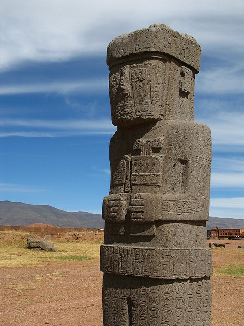
The area of the small semi-subterranean temple is accessed by a series of descending steps. The temple itself is made up of 48 pillars made of red sandstone. Its most notable feature are the many styles of carved stone heads that are set into the surrounding walls.
In the centre of the underground temple stands a carved stone monolith known as “El Fraile” (The Friar). This statue was carved out of red andesite, a type of very hard granite that is common to the region.
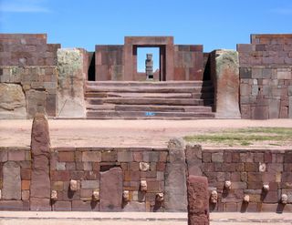
Situated to the side of the Akapana pyramid is a large courtyard and ceremonial platform known as the Kalasasaya. The courtyard is over three hundred feet long. It is entered through a flight of seven steps cut into the centre of the eastern wall, leading to an imposing gateway made out of enormous blocks of stone.
The imposing Gateway of the Sun
The interior of the courtyard contains two carved monoliths, one of which weighs over twenty tons, as well as the most famous artifact of the entire site, which is the monumental “Gateway of the Sun”, incorporating the image of the “weeping god”.
This gateway has been carved from a single block of andesite, and has been cut to form a large doorway with niches on either side. Above the doorway is an elaborate bas-relief of the central deity, believed by the local Indians to have been their Creator-God Viracocha.
The deity is flanked on either side by thirty intricately carved glyphs, known as Chasquis, as well as a row of eleven other icons that are carved along the bottom of the panel. Another feature of the Kalasasaya temple is the “calendar wall”, consisting of ten large stone pillars set in a modern wall.
An important point that visitors to Tiwanaku should bear in mind, is that the entire area was reconstructed by archaeologists in the 20th century. So most of what can be seen in the Kalasasaya courtyard today bears little resemblance to what was originally found, but rather reflects what these archaeologists thought would make the most impressive memorial.
The cyclopean ruins of Puma Punku
Finally, there is the site located about a mile away from the main temple complex known as Puma Punku (Door of the Puma). This consists of little more than a series of scattered blocks of stone, except for the fact that some of these stones weigh anywhere from 100 to 150 tons!
Confronted with megalithic ruins of such complexity and size, modern historians were challenged to come up with a history that would explain them, especially since they were so dramatically different from anything else found on the South American continent.
The history they devised is the history that is taught to every schoolchild in Bolivia today, and is a source of immense national pride. The following is an extract from a local travel guide which gives a popular rendering of the story that historians came up with.
“This civilization arose in the 6th century BC, and local Indian legends described the city as the capital of the bearded white god Wiracocha.
“Tiahuanaco endured a thousand years more than Rome, and almost 2000 years more than the Inca civilization that built Machu Picchu. Moreover, the inhabitants had developed a system of agriculture that turned barren Altiplano land into the breadbasket of their society.
“The city of Tiahuanaco, capital of a powerful pre-Hispanic empire that dominated a large area of the southern Andes and beyond, reached its apogee between 500 and 900 AD. Its monumental remains testify to the cultural and political significance of this civilization, which is distinct from any of the other pre-Hispanic empires of the Americas.
“The classic, or fourth period (300-700 AD), is perhaps the most dramatic, with its huge stone structures that watch over the site today.
 “During its peak, the capital of Tiwanaku boasted a huge stone-faced pyramid, cut stone enclosures, elite residences, exquisitely decorated buildings, a system of subterranean canals, and at least four square kilometers of residential buildings.
“The Tiwanaku imperial economy was based on the intensive utilization of raised fields, camelid pastoralism, terrace agriculture, an extensive exchange and colonial system, and the organization of large numbers of laborers for state projects. There was a rigid social and political hierarchy expressed in elaborate art and architectural styles.
“The ruins of Tiahuanaco bear striking witness to the power of the empire that played a leading role in the development of the Andean pre-Hispanic civilization.
“The buildings of Tiahuanaco are exceptional examples of the ceremonial and public architecture and are of one of the most important manifestations of the civilizations of the Andean region.
“Clearly, the ruins of Tiahuanaco show a great ceremonial center, and a city that numbered, at its height, more than 20,000 inhabitants. Researchers have divided this civilization into five distinct periods.
“The civilization seems to have totally vanished by 1200AD.” (View Source)
The history outlined above tells an inspiring tale of humble beginnings that lead on to greatness – of imposing architecture, sophisticated engineering and advanced agriculture that speak of the glories of a now vanished era. The unfortunate truth is that all of this is “pure bunk”.
The idea that a powerful Bolivian pre-Hispanic empire once dominated the region for thousands of years is complete fiction. There was no great capital city housing 20,000 citizens, no elite residences, no decorated buildings, and certainly no agriculture that turned the barren Altiplano (high plateau) into a giant breadbasket.
The droll part about this so-called “history”, was that archaeologists and historians had to frame their history of Tiwanaku to conform with the current scientific paradigm, which holds that the earliest civilization on the planet began 5,000 years ago with the Sumerian and Egyptian cultures.
So operating within this paradigm, historians came up with a scenario beginning in the 6th century BC, and ending with the mysterious disappearance of the entire Tiwanaku culture in the 12th century AD, thus conveniently disposing of it before the arrival of the Incas of Peru, early in the 13th century AD.
Yet if these scientists had been prepared to undertake an honest enquiry into the evidence, they would have found some interesting facts which point to the likelihood that, many thousands of years ago, Tiwanaku was originally located at sea level, at that it was at one time a flourishing seaport.
The first fact is that the ruins of Tiwanaku are at an altitude of over 12,000 feet (3,650 metres) above sea level. This is an altitude where most plants will not grow, and corn in particular will not ripen. Its average annual temperature is 45 degrees Fahrenheit (7.7 degrees C), with an average annual rainfall of 24 inches (630 mm).
Based on this evidence alone, it is clear that the present location of Tiwanaku could not possibly have supported an advanced civilization involving tens of thousands of people, especially since some of the agricultural terraces that surround the existing ruins reach as high as 18,000 feet.
The second interesting fact concerns Lake Titicaca, located just a few miles to the west of Tiwanaku. Although it is considered to be the world’s highest fresh water lake, in earlier times it was an inland salt water sea, before being suddenly thrust up to its present height of 12,500 feet (3,800 metres) above sea level.
This is borne out by the fact that the shoreline of the lake is littered with millions of fossilized seashells. It also still retains a slightly saline content, which accounts for the fact that ocean dwelling fish, as well as creatures such as seahorses, continue to be caught in the lake to this day.
Lake Titicaca drains to the south along the Altiplano plateau, spreading out over the Desaguadero Basin and on toward Lake Poopó. If the lake actually had been filled with sea water in earlier times, we should expect to find evidence of evaporated salt deposits in the region, and that is exactly what we do find.
The great salt lake of Salar de Uyuni
One of the most spectacular features in all of Bolivia is the Salar de Uyuni. It is the world’s largest dried up salt bed. It covers an area of over 4,000 square miles (10,500 square kms), which is one third of the size of Belgium, or twenty-five times larger than the famous Bonneville salt flats in Utah.
The crust that is found on the surface of Salar de Uyuni has a thickness of about 33 feet (10 metres), and is made up of eleven separate layers. It is estimated that the dry lake itself contains about ten billion tons of salt, as well as being the world’s richest source of lithium.
The existence of all this salt lends credibility to the theory that Tiwanaku was once a seawater port. And nowhere is there better evidence of this than in the megalithic blocks of stone that can be found at Puma Punku, situated a short distance away from the main ceremonial centre of the city.
Exquisite designs carved into the polished granite
Whereas the main ruins of Tiwanaku are clearly linked with the ceremonial, religious and social focus of this ancient culture, the gigantic blocks of stone that lie strewn all over the plateau at Puma Punku are distinctly different. They seem to possess a unique character of their own.
These megalithic stones are bluish-gray in colour, and generate a metallic tone when struck. They also appear to be the product of an advanced system of technology, as individual blocks have exquisitely cut edges and indentations in a variety of patterns and designs.
Recessed double-crucifix design
One of the most common of these indentations is the symbol of the cross, a double-crucifix design deeply recessed into the granite with pure, clean lines, which could only have been produced with the aid of highly sophisticated stone-cutting tools. Other motifs include arrows, circles and niches unlike anything seen at Tiwanaku.
Easily the most striking feature of the entire site are the gargantuan precision-made H-blocks made of andesite that once formed the walls. Each of these stones is so intricately carved that it has about 80 different surfaces, yet each of these surfaces seems to have been polished into a perfectly smooth finish.
In assembling the walls of Puma Punku, each stone was finely cut to interlock with adjacent stones, and was designed to form load-bearing joints that fitted together without the use of mortar. These joints are so precise that not even a razor blade can fit between the stones.

Examples of the indentations carved in stone for the metal clamps that held these stones together
Another feature of the stonework at Puma Punku was the use of metal clamps or ties. For example, the side walls of the water channels were built with upright stone slabs held together with I-shaped metal clamps which were recessed into the stone.
When analysed in the laboratory, these clamps were found to be made of an unusual alloy, comprising copper, arsenic, nickel, silicon and iron. It is also worth mentioning here that this same system of using metal clamps was found at the Ahu Vinapu megalithic wall on Easter Island.
The entire site of Puma Punku speaks of an ancient civilisation suddenly afflicted by appalling tragedy, as catastrophic forces of nature devastated the region, destroying all but the few remnants that can be seen strewn around the site today.
Who can solve the riddle of my past?
The story of who these people were, how they built their cyclopean structures, and how they met their end, would appear to be lost forever in shrouded legends of antiquity. Yet there is one relic which could be the key to unravelling the mystery of the past. It is the magnificent Gateway of the Sun itself.
Dedicated to the “weeping God” Viracocha, whose tears can still be seen immortalised in stone, the Sun Gate stands in mute splendour as it gazes over the stark plateau of the Altiplano, inviting all who pass that way to solve the riddle of its past.


August 7th, 2024 at 6:55 am
This was an extremely wonderful article. Thank you for supplying this information.
August 14th, 2024 at 9:57 pm
Loving the info on this internet site, you have done outstanding job on the blog posts.